Wednesday, August 31, 2005


Augus 31, 2005.

A cloudy and muggy day today. Morning low was 18.6*C and afternoon high was 24.0*C. 4 mm of rain fell overnight. A 9:50 pm temperature was 22.1*C.

Tuesday, August 30, 2005


August 30, 2005

A cloudy and muggy day here today. Light showers developed in the evening, expecting rain for the next couple of days before clearing on Friday. Today's high was 24.4*C and the low was 19.2*C. At 10:35 pm temperature was 20.3*C. On a sad note the tragic situation continues in Louisianna and Mississippi. Levees in New Orleans have broken flooding the city worse than it already was.

Monday, August 29, 2005


August 29, 2005.

Hurricane Katrina came ashore this morning to the east of New Orleans sparing the city total devastation but causing devastation none the less. Also hard hit were the states of Alabama and Mississippi. At 7:50 pm she is well inland in Mississipi and still a cat 1. Later this week we can expect some rain from the remenents of this system.

Our weather today was sunny and muggy with SW winds. Warm last night with a low of 17.8*C today's high was 27.0*C. Currently it is 21.8*C. The rest of the week should be muggy and damp with rain beginning Tuesday night.

Sunday, August 28, 2005

August 28, 2005.


Today was another beautiful day. We are presently on the back side of a high pressure system, so experiencing sw winds. Today's high was 25.2*C and the low was 13.3*C. The temperature at 8:00 pm was 20.0*C.

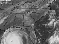
Today Hurricane Katrina was upgraded to a cat 5.It is in the GOM south of New Orleans. Landfall is expected there Monday morning. This is one of the strongest hurricanes ever recorded and damage is expected to be extensive. Winds of 165 mph are called for, and pressure today was 902 mb the fourth lowest on record.


A satellite picture from earlier today showing the size of this monster storm.


Saturday, August 27, 2005


August 27, 2005

Another sunny day with low humidity. Morning low was 12.6*C afternoon high was 27.8*C.Light nw winds today. Hurricane Katrina is a cat 3 with New Orleans in its sights. Could be catastrophic if it pans out.

Friday, August 26, 2005


August 26, 2005.

A nice summer day here with light NW winds and low humidity. A great night for sleeping last night with a low of 11.1*C. Today's high was 25.3*C. The wind has recently switched to the SW, so we can probably expect a warm and muggy day tomorrow. At 10:50 pm it is currently 17.2*C.
On the hurricane front,Katrina crossed over Florida last night as a category 1, today in the GOM it was upgraded to a cat 2. Expected to be a 3 or 4 when makes landfall again. Track today looks like around the Mississippi Louisiana border late Sunday, early Monday. Still uncertain for our area late next week, but could be interesting.

Thursday, August 25, 2005


August 25, 2005

A fall like day out there today with a cool north wind. Some drizzle and light showers around giving a trace. Today's high was 18.5*c and the low was 14.0*C. At 9:15 pm it was 15.0*C. Katrina is now a hurricane soon to make landfall in Florida.

Wednesday, August 24, 2005


August 24, 2005

Sun and cloud to start the day with a high of 24*C. By late afternoon it had clouded over with cu, which gave parts of the city heavy rain, however here in Clayton Park I measured only 3 mm. Wind is now out of the north giving us cooler air. Today's low was 14.2*C. It is currently 17.0*C a 9:40 pm.
On the surface analysis take note of TS Katrina off of Florida. It is expected to be a hurricane when it reaches Florida then diminish as it crosses the state only to reintensify in the GOM coming ashore near the panhandle. A few models show it coming back towards the NE and up the east coast mid to late next week. Stay tuned.

Tuesday, August 23, 2005


August 23, 2005.

Another sunny day here today with lower humidity. Morning low was a warm 18.4*C and the afternoon high 27.4*C. Some late afternoon thundershowers developed over the central and northern parts of the province. Winds were light from the south today and the barometer was on the rise. Temperature at 9:45 m was19.3*C.

Monday, August 22, 2005


August 22, 2005

Well another muggy and uncomforable day. The day started cloudy with some sunny periods late to mid morning, then back to cloud for the remainder of the day. Dew point again was 20*C with the humidex in the mid 30's. The high today was 24.9*C and the low was 17.9*C. Not much sleep last night. AT 9 pm temperature was still 21.1*C. A cold front is moving through, have to wait to see if any change in humidity. Wind was calm and light from the SW.
Just before supper a severe thunderstorm moved through Scotts Bay and across to Northern NS area.

Sunday, August 21, 2005


August 21, 2005

What a difference a few days makes. After enjoying cool comfotable weather,humidity today climbed to uncomfortable levels. Sun this morning turned to cloud and drizzle before the sun reappeared late this afternoon only to fog over in the evening. This mornings low 17.6*C
and the high was 24.1*C. With dew points around 20*C it was uncomfortable. At 10pm the temperature was still19.6*C.

Saturday, August 20, 2005


August 20, 2005

A sunny day for most of the day until mid to late afternoon when clouds from an approaching warm front moved in. Todays high was 23.2*C and the low today was 11.8*C. Temperature at 10:15 pm was 18.4*C. We had a light sprinkle of rain mid evening as the front neared.

Barometer fell slowly during the day, currently 102.2 kPa, down from 102.7 kPa earlier today.

Friday, August 19, 2005


August 19, 2005

Yet another sunny day here in Halifax, a cool start to the day 9.8*C with a high of 22*C. High pressure is still influencing our weather but should move off tomorrow. Frost last night in NW NB,
seems early. Temp at 9:00 pm 16.3*C.

Thursday, August 18, 2005


August 18, 2005

Today felt like an early Fall day. Sunny all day with a NW wind. The high today was 22.1*C
and the morning low was 10.7*C. We are under the influence of a high pressure system so the barometer is rising and thankfully the humidity has dropped . Temperature at 8:30 pm was 16.9*C, it will be a coolnight but great for sleeping.

Wednesday, August 17, 2005

August 17, 2005

A quiet day weather wise here. A cloudy morning gave way to a sunny afternoon. Morning low of 13.6*C and a high of 23.2*C

Tuesday, August 16, 2005

August 16, 2005

After waking up to thick radiation fog, the sun broke through mid morning and we experienced a sunny and pleasant day with light SE winds. Morning low was 10.6*C and the afternoon high was 21.6*C.

Monday, August 15, 2005

August 15, 2005

Rain began overnight giving a total of 18 mm. Ended early afternoon with clearing visible in the horizon to the NW. Again today winds were very light. Not much change in temperature, morning low of 15.9*C and a high of 17.1*C. However in the evening temperature began to drop after sunset to 15.2*C by 8:55 pm.

Sunday, August 14, 2005

August 14, 2005

A quiet day weather wise. Started out sunny but clouded over by noon hour, stayed that way until early evening when a shower gave us 3 mm. More rain forcasted for over night and tomorrow with a possible 20 mm. I expect we may get more if thundershowers develop in this unstable airmass.

Today's high 25.9*C
Today's low 16.9*C
Winds light SW
Barometer slowly rising to 101.5 kPa at 8 pm

Saturday, August 13, 2005


Saturday August 13, 2005

A warm front moved through this morning giving rain at times heavy. Total rainfall in my gauge here in Clayton Park West (Halifax, Nova Scotia) was 18 mm.

Temperatures slowly climbed during the day from a morning low of 15.4*C to a High of 19.8*C shorly after supper.

Also note on the surface plot, Tropical Storm Irene. It is not expected to impact Nova Scotia, it is currently curving around a Bermuda high Before it turns NE as it gets caught in the jet stream and is pushed out to sea.