Wednesday, September 07, 2005


September 7, 2005.

If you are a fan of nice weather the high pressure system we are under is your best friend, but for those who like active weather, this is boring, big time. Yet another sunny day here with a high of 24.0*C and south west winds gusting to 25 km. Our morning low was 10.3*C. At 9:15 pm temperature was 17.1*C.
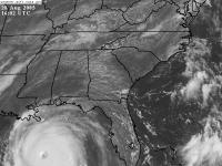
TS Nate is now a hurricane, looks like it will pass to the south of Bermuda.TD 16 is now a TS called Ophelia off the coast of Florida. Models still in disagreement but gut feelings tell me it is going to cross Fl. into the GOM. Meanwhile Maria is being torn apart by sheer as it enters colder water.

Tuesday, September 06, 2005


September 6, 2005

We experienced our coolest morning of the season today with a low of 9.0*C. Over all it was a good day with light winds and a high of 22.2*C, with sunshine all day long. Warmer tomorrow with the high in the mid twenties and SW winds.

The tropics remain busy TD 15 has become TS Nate. It is expected to follow Maria of to the NE after it crosses or comes very close to Bermuda. A new TD has formed off the SE coast of Florida, TD 16. It looks like it is going no where fast. Not much agreement among the models today but the NHC has it going ashore in NE Florida.

Monday, September 05, 2005


September 5, 2005.

A beautiful late summer day today with low dew points and a north wind to keep it from getting too hot. This mornings low was 11.5*C while the afternoon high made it to 21.8*C. At 10:00 pm the temperature was 14.4*C. Looks like it will be coolest night we have had in a while.

This week looks good for back to school. Through mid week things will warm up but so will the humidity as we get back in the SW flow but it should be short lived as NW winds near the end of the week return.

Hurricane Maria is still out there but no concern to us. Another TD formed today, TD 15 SW of Bermuda. If it forms into a storm it will be known as Nate.

Sunday, September 04, 2005


September 4, 2005.

Another quiet day weather wise here in Halifax. Woke up to suuny skies and remained that way for the day with a few cloudy periods around this afternoon. The morning low was 12.5*C and the afternoon high was 24.3*C. At 9:00 pm the temperature was 17.5*C.

Maria formed into a hurricane over night and could intensify to a cat 2. Thanks to a strong high pressure system moving into our area the hurricane will be pushed to the NE well out to sea.

Saturday, September 03, 2005


September 3, 2005.

Another sunny and warm day here today. Not humid, with NW winds gusting to around 30 km. This mornings low was 15.1*C and the high was 24.8*C. At 8:20 pm the temperature was 18.8*C.

TS Maria continues to strengthen and could most likely be upgraded to a hurricane tonight or tomorrow morning. As it stands now it will likely veer off to the northeast and have no effect on us.

Friday, September 02, 2005


September 2, 2005.

Today was another sunny day, the only differance was the humidiy we have been experiencing has gone. The wind has shifted to the west making it much more pleasant. The high was 25.5*C and the low was 14.7*C. At 8:50 pm it was 19.2*C.

Another tropical sorm has formed, named Maria. his will have to be wached closely as it could have implications for us here in N.S.


Thursday, September 01, 2005

August stats.

Av min 14.5*C
Av max 24.2*C
Mean temp 19.4*C

Min minimum 9.8*C (19)
Max minimum 19.2*C (30)

Min maximum 17.1*C (15)
Max maximum 28.4*C (8)

Total rainfall 71 mm

September 1, 2005.

Wow, where did August go? It will cartainly be a month to forget for the poor souls in Louisianna and Mississipi. I am afraid it will be years, if ever before the recover from this.

Here a home last night was one of the warmest nights in recent memory. The morning low was 21.6*C and very humid. Today was cloudy with south winds gusting to 60 km at times. Early afternoon the rain began and between 1 and 2 pm we received 16 mm. At 8:30 pm the temperature is 19.1*C so hopefully a better night for sleeping.

Wednesday, August 31, 2005


Augus 31, 2005.

A cloudy and muggy day today. Morning low was 18.6*C and afternoon high was 24.0*C. 4 mm of rain fell overnight. A 9:50 pm temperature was 22.1*C.

Tuesday, August 30, 2005


August 30, 2005

A cloudy and muggy day here today. Light showers developed in the evening, expecting rain for the next couple of days before clearing on Friday. Today's high was 24.4*C and the low was 19.2*C. At 10:35 pm temperature was 20.3*C. On a sad note the tragic situation continues in Louisianna and Mississippi. Levees in New Orleans have broken flooding the city worse than it already was.

Monday, August 29, 2005


August 29, 2005.

Hurricane Katrina came ashore this morning to the east of New Orleans sparing the city total devastation but causing devastation none the less. Also hard hit were the states of Alabama and Mississippi. At 7:50 pm she is well inland in Mississipi and still a cat 1. Later this week we can expect some rain from the remenents of this system.

Our weather today was sunny and muggy with SW winds. Warm last night with a low of 17.8*C today's high was 27.0*C. Currently it is 21.8*C. The rest of the week should be muggy and damp with rain beginning Tuesday night.

Sunday, August 28, 2005

August 28, 2005.


Today was another beautiful day. We are presently on the back side of a high pressure system, so experiencing sw winds. Today's high was 25.2*C and the low was 13.3*C. The temperature at 8:00 pm was 20.0*C.

Today Hurricane Katrina was upgraded to a cat 5.It is in the GOM south of New Orleans. Landfall is expected there Monday morning. This is one of the strongest hurricanes ever recorded and damage is expected to be extensive. Winds of 165 mph are called for, and pressure today was 902 mb the fourth lowest on record.


A satellite picture from earlier today showing the size of this monster storm.


Saturday, August 27, 2005


August 27, 2005

Another sunny day with low humidity. Morning low was 12.6*C afternoon high was 27.8*C.Light nw winds today. Hurricane Katrina is a cat 3 with New Orleans in its sights. Could be catastrophic if it pans out.

Friday, August 26, 2005


August 26, 2005.

A nice summer day here with light NW winds and low humidity. A great night for sleeping last night with a low of 11.1*C. Today's high was 25.3*C. The wind has recently switched to the SW, so we can probably expect a warm and muggy day tomorrow. At 10:50 pm it is currently 17.2*C.
On the hurricane front,Katrina crossed over Florida last night as a category 1, today in the GOM it was upgraded to a cat 2. Expected to be a 3 or 4 when makes landfall again. Track today looks like around the Mississippi Louisiana border late Sunday, early Monday. Still uncertain for our area late next week, but could be interesting.

Thursday, August 25, 2005


August 25, 2005

A fall like day out there today with a cool north wind. Some drizzle and light showers around giving a trace. Today's high was 18.5*c and the low was 14.0*C. At 9:15 pm it was 15.0*C. Katrina is now a hurricane soon to make landfall in Florida.

Wednesday, August 24, 2005


August 24, 2005

Sun and cloud to start the day with a high of 24*C. By late afternoon it had clouded over with cu, which gave parts of the city heavy rain, however here in Clayton Park I measured only 3 mm. Wind is now out of the north giving us cooler air. Today's low was 14.2*C. It is currently 17.0*C a 9:40 pm.
On the surface analysis take note of TS Katrina off of Florida. It is expected to be a hurricane when it reaches Florida then diminish as it crosses the state only to reintensify in the GOM coming ashore near the panhandle. A few models show it coming back towards the NE and up the east coast mid to late next week. Stay tuned.

Tuesday, August 23, 2005


August 23, 2005.

Another sunny day here today with lower humidity. Morning low was a warm 18.4*C and the afternoon high 27.4*C. Some late afternoon thundershowers developed over the central and northern parts of the province. Winds were light from the south today and the barometer was on the rise. Temperature at 9:45 m was19.3*C.

Monday, August 22, 2005


August 22, 2005

Well another muggy and uncomforable day. The day started cloudy with some sunny periods late to mid morning, then back to cloud for the remainder of the day. Dew point again was 20*C with the humidex in the mid 30's. The high today was 24.9*C and the low was 17.9*C. Not much sleep last night. AT 9 pm temperature was still 21.1*C. A cold front is moving through, have to wait to see if any change in humidity. Wind was calm and light from the SW.
Just before supper a severe thunderstorm moved through Scotts Bay and across to Northern NS area.

Sunday, August 21, 2005


August 21, 2005

What a difference a few days makes. After enjoying cool comfotable weather,humidity today climbed to uncomfortable levels. Sun this morning turned to cloud and drizzle before the sun reappeared late this afternoon only to fog over in the evening. This mornings low 17.6*C
and the high was 24.1*C. With dew points around 20*C it was uncomfortable. At 10pm the temperature was still19.6*C.

Saturday, August 20, 2005


August 20, 2005

A sunny day for most of the day until mid to late afternoon when clouds from an approaching warm front moved in. Todays high was 23.2*C and the low today was 11.8*C. Temperature at 10:15 pm was 18.4*C. We had a light sprinkle of rain mid evening as the front neared.

Barometer fell slowly during the day, currently 102.2 kPa, down from 102.7 kPa earlier today.